Maritime Archaeology Updates

Diving Deeper with the Maritime Archaeology Trust

Tag: discovery (page 1 of 2)

#MuseumWeek2017: Theme of the day, TRAVEL!

Museum Week is an international online event that is running from 19th to 25th June 2017. Organised in collaboration with UNESCO, the Museum Week is a chance for heritage institutions across the world to share and talk about our passion for heritage with the public through social media. This year we are celebrating equality by dedicating the Museum Week to all women in the world.

The Maritime Archaeology Trust will be sharing with you our take on Museum Week. In collaboration with the Shipwreck Centre and Maritime Museum on the Isle of Wight we will be looking through their collections and bring you artefacts and histories that are linked in with the theme of the day.

Saturday’s theme for the week is TRAVEL!

One rupee from 1917. Source: https://www.marudhararts.com/e-shop/pid-no-6566/bank-note-of-india/british-india-notes/k-g-v-/british-india-one-rupee-note-of-king-george-v-of-1917-.html

Artefacts recovered from shipwrecks have a natural connection with travel. Either they have been on board the ship and travelled to the same destinations or they originate from the destinations visited by the ship. The Shipwreck Centre’s collection has numerous items that have a connection to maritime travel. Some are extremely fascinating to the viewer, such as the “Feejee mermaid” that was discussed in a previous blog post.

Indian rupees on display at the Shipwreck Centre from the SS Camberwell. Credits: Shipwreck Centre and Maritime Museum

On the wreck of the SS Camberwell, divers found Indian rupee banknotes which were still recognisable. Remarkably these had survived for 70 years before they were brought back to the surface. The SS Camberwell sunk on the 18th May 1917 when it struck a mine and sunk 6 miles SE of Dunnose Head on the Isle of Wight. Sadly seven people perished with the sinking of the ship, all with Indian heritage.

India was officially recognised as a British colony in 1858 when the Crown took control of India from the East Indian Trading Company. Lascars, or Indian sailors had already been employed by the EITC as sailors in the 17th century. With the Royal Navy’s demand for sailors during wars the number of Indian sailors quickly rose. By 1917 the number of Indian sailors on British registered vessels were up to over 51 000.

The rupees found on the SS Camberwell tell the journey of the people connected with the ship. Like the mermaid and the HMS Victory’s logbook mentioned earlier this week, the bank notes have travelled far before ending up on display at the Shipwreck Centre on the Isle of Wight. Just like the people on board the SS Camberwell before it sank in 1917.

#MuseumWeek2017: Theme of the day, BOOKS!

Museum Week is an international online event that is running from 19th to 25th June 2017. Organised in collaboration with UNESCO, the Museum Week is a chance for heritage institutions across the world to share and talk about our passion for heritage with the public through social media. This year we are celebrating equality by dedicating the Museum Week to all women in the world.

The Maritime Archaeology Trust will be sharing with you our take on Museum Week. In collaboration with the Shipwreck Centre and Maritime Museum on the Isle of Wight we will be looking through their collections and bring you artefacts and histories that are linked in with the theme of the day.

The Friday theme during Museum Week is BOOKS!

Logbook from the whaling ship Diana from hull, which accounts for a very tragic story. Source: http://www.mylearning.org/ships-log-of-the-diana/p-4300/

Or in our case, more accurately logbooks! A logbook or ship’s log is a record of important events that happened during the ship’s journey. This also includes management, operation and navigation of the ship.

The logbook was a key part of navigating a ship. Navigation is largely based on defining the latitude and longitude of the ship’s location. The longitude is the more difficult one to determine, as it requires the sailor to know the local time to determine what time zone they were travelling through, and as such determine their location by combining the ship’s latitude position. Medieval sailors were unable to determine the latitude-longitude completely accurately, due to the technology that was available to them at the time. As such the sailors heavily relied on the dead reckoning system. The dead reckoning principle works the following way. The sailor would start by taking a known or assumed position of the ship. Then the heading and the speed of the ship from this location would be measured, as well as the speed of the ocean currents, the leeward (downwind) drift, and how long the ship spent at each heading. Based on this information, the navigator could determine the course of the ship and how far the ship had travelled. This was noted down in the logbook, which was then used to as a reference to check the accuracy of the predicted dead reckoning.

A ship’s logbook holds a huge wealth of material for maritime archaeologists. Finding a ship’s logbook is like finding a gold mine. We can retrace the journey of the ship from the logbook and compare that to any remains we may have found. This is valuable when trying to determine the identity of a wreck for example. It also gives us a great insight into what life on board was like. For a great example is an extract from the logbook of the Halsewell.  The Halsewell was a merchant ship based in the East India Company. There is a record in their logbook from 19th October 1781, where Lord Nelson (then Captain) recruits experienced sailors for the Navy, leaving the ship with only “foreigners and servants”.

Captain Nelson recruiting experienced sailors from the Haslewell. Source: http://www.bl.uk/learning/timeline/item105531.html

The Shipwreck Centre also holds logbooks in their collection. An example can be seen here of the logbook from the HMS Victory which subsequently became the logbook of the HMS Duke of Wellington, the ship that replaced the HMS Victory as the Port Admiral flagship at Portsmouth between 1869 and 1891 (McKay 1987:9). Next time you visit the Shipwreck Centre and Maritime Museum on the Isle of Wight, try to spot the logbook which is on display next to old toothpaste and wood from the Mary Rose!

Cadet logbook of the HMS Victory on display in the Shipwreck Centre. Source: Shipwreck Centre and Maritime Museum

#MuseumWeek2017: Theme of the day, STORIES!

Museum Week is an international online event that is running from 19th to 25th June 2017. Organised in collaboration with UNESCO, the Museum Week is a chance for heritage institions across the world to share and talk about our passion for heritage with the public through social media. This year we are celebrating equality by dedicating the Museum Week to all women in the world.

The Maritime Archaeology Trust will be sharing with you our take on Museum Week. In collaboration with the Shipwreck Centre and Maritime Museum on the Isle of Wight we will be looking through their collections and bring you artefacts and histories that are linked in with the theme of the day.

The Little Mermaid by E.S. Hardy, 19th century painting. Source: https://fineartamerica.com/featured/little-mermaid-e-s-hardy.html

The Thursday theme is, STORIES!

We have a special one for you today! There are probably very few people in the world who haven’t heard about the myth of mermaids. But did you know that in the Victorian period “real” mermaids were sold as collectables?

The myths of the mermaids and mermen date back as far as 1000 BC. The Assyrian legends told of a queen who accidentally killed her lover. In despair she threw herself into the sea to transform into a fish but the water only transformed half of her body and as such she became half fish and half human.

Stories of similar creatures can be found across the world. In Africa the legend of Mami Wata, a powerful water spirit, sometimes takes the shape of a mermaid. She is not too dissimilar from the legends of European mermaids (think HC Andersen’s “The Little Mermaid”). Interestingly the legend of the mermaid Lasirn in the Caribbean has resemblance to both the African and European legends. We also find records of mermaid stories and sightings from the American, Inuit, Indonesian, Australian and Japanese cultures.

A “Feejee merman” can be found in the collection at the Shipwreck Centre and Maritime Museum on the Isle of Wight. Image credits: The Shipwreck Centre and Maritime Museum

The collectable mermaid hoax has been around for centuries. However, the most famous version was created by an American conman, P.T. Barnum, in 1842. Known as the “Feejee mermaid”, it was said that this mermaid corpse had been caught near the Fiji islands in the South Pacific. In actual fact the head of the “mermaid” was of a monkey while the tail was from a fish. Put together and dried out it does make for a quite convincing deep-water creature. During the Victorian period people would buy these “mermaids” as collectables from their trips. Especially in Japan this became a very popular thing to sell to the tourists. The “Feejee mermaid” is now often referred to as the Japanese monkey-fish.

When you visit the Shipwreck Centre and Maritime Museum on the Isle of Wight be sure to check out the “Feejee mermaid” we have in our collection!

#MuseumWeek2017: Theme of the day, MUSIC!

Museum Week is an international online event that is running from 19th to 25th June 2017. Organised in collaboration with UNESCO, the Museum Week is a chance for heritage institions across the world to share and talk about our passion for heritage with the public through social media. This year we are celebrating equality by dedicating the Museum Week to all women in the world.

The Maritime Archaeology Trust will be sharing with you our take on Museum Week. In collaboration with the Shipwreck Centre and Maritime Museum on the Isle of Wight we will be looking through their collections and bring you artefacts and histories that are linked in with the theme of the day.

Wednesday’s Museum Week theme is MUSIC!

Musical instruments found during the excavation of the Mary Rose. Images credits: Mary Rose Museum [Source: http://www.maryrose.org/discover-our-collection/her-crew/life-on-board/]

Music has always been an important aspect in seafaring. Musical instruments were used by the crew for entertainment, but also for keeping pace when rowing and calling for action. When excavating the Mary Rose archaeologist discovered a number of musical instruments in the crew belongings on the orlop deck. These included tabor pipes, a tabor/drum and the earliest example of a shawm which is an early form of oboe. Famously during the sinking of the Titanic, records state that the band was playing on deck while the ship was sinking to help keep the passengers calm.

Wallace Hartley’s violin. He was one of the band members on the Titanic. Image credit: BNPS.co.uk [Source: http://www.dailymail.co.uk/news/article-2293232/Water-stained-violin-proven-played-brave-bandmaster-Titanic-sank.html]

Although it is not a musical instrument as such, the Bosun’s whistle has a long history in the seafaring world. For example, it is thought that the Roman’s used a type of whistle to keep the rowers in pace on their war ships. The whistle is commonly used in the Navy. It is used to attract the attention of the crew before handing out orders. Different calls have different meanings and sometimes just the whistle call itself is enough to deliver the message, such as the “Carry On” command.

Examples of the Bosun’s Whistle can be found at the Shipwreck Centre. The whistles are located in the bottom right hand corner of the picture. Image credits: The Shipwreck Centre and Maritime Museum [Source: https://photos.google.com/share/AF1QipNGxx3z33Z8ji16TBFJCoqpIbaSu3dwQsMrGIx99WACfB8hJnVfJ8a9kHFcHsvSSQ?key=YUhSYzBQdFZIWGM3TFNUclJlXzNCSDhCUU0yZ09n]

Of course, the use of musical instruments was not always necessary in order to make music. Sea shantys were commonly sung by the crew while working on board the ship. It helped keep the crew’s morale up while completing tedious tasks.

Qatar Marine Archaeological Project (QatarMAP)

The Qatar archaeological research and exploration project built on the work undertaken by the Qatar Museums to locate and record the submerged cultural heritage. The aim of underwater fieldwork was to begin condition surveys of known submerged marine archaeological heritage sites. The results will enhance the maritime Historic Environment Record with the additional benefit of making the underwater heritage resource more accessible to the Qatari population.

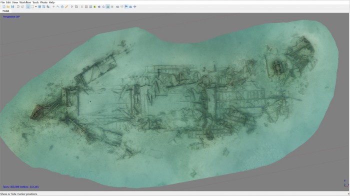
Rendered photomosaic of 50m long wreck recorded during the first week of diving

In the long term, areas of the sea bed will be surveyed to locate and identify more of Qatar’s underwater cultural heritage which includes submerged landscapes as well as shipwrecks. The Maritime Archaeology Trust (MAT) is working with the University of York, the Qatar Museums and Qatar University on the Qatar Maritime Archaeology Project (QatarMAP) to carry out these marine archaeological investigations. MAT divers visited Qatar in early May and diving from the dive boat Janan, with the help of divers from the Qatar University, carried out photographic survey over some shipwreck sites to produce 3D photomosaics which were calibrated with measuring scales positioned at different locations.

Diver from the Maritime Archaeology Trust conducting a 3D photomosaic survey on debris at the gravel pile

The MAT dive team are now back in Qatar to continue the work. Along with continued processing of data collected during the first week’s visit, testing and checking of geophysical equipment has been taking place until the bad weather abates which is likely to be this evening.

Menhir de la Tremblais

Near the village of Saint-Samson-sur-Rance, in Brittany, France, we find this interesting Neolithic piece of stone.

Pierre Longue menhir of Thiemblaye

The menhir stands alone at 6 meters in length, leaning at just over  45 degrees. It is a large block of granite and quartz, with a relatively polished, flat look.

Most of the time that is all it seems to be. However, when the sun hits it just right, beautiful markings and carvings appear. Carvings of crosses, leaves, axes, waves and various animals.


There are several legends surrounding this monument. One legend says it is one of three stones closing the entrance to hell. This belief gave it the name “Bonde de l’Enfer,” loosely meaning “Leap From Hell.”

Another legend says that a young girl who wants to get married should climb on top of the menhir and slide down in her “birth pants.” Subsequently, she will be wed within a year.

A final legend tells a story of Samson of Dol who faced the temptations of the Devil nearby, and when the Devil failed, it whipped the stone, creating some of the marks we can see today.


Find this interesting?
Follow us on Twitter
Like us on Facebook

Forgotten Wrecks of the Devon Coast: Geophysics and Diving

WholeAreaMap

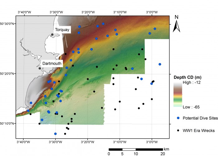
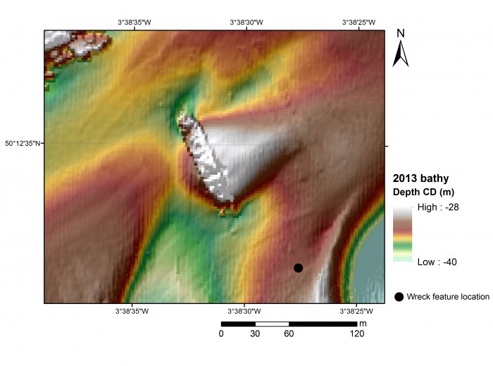
Distribution of First World War wrecks within the Devon study area (image credit: Contains public sector information, licensed under the Open Government Licence v2.0, from the Maritime and Coastguard Agency).

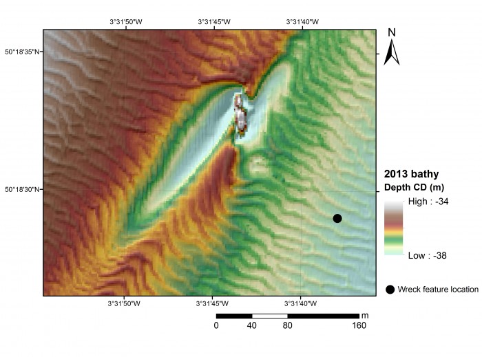
As part of the Forgotten Wrecks project this summer the Maritime Archaeology Trust sent out a team of divers to find and document a number of WW1 wrecks off the South Devon Coast. In order to assist the divers in finding these wrecks bathymetric maps were consulted. Much like navigational charts used by mariners these maps show the topographic features of the seafloor. However, modern techniques such as multibeam bathymetry, paint a far higher resolution image of the seafloor with measurements made every few metres.  As a result, even fine details such as the orientation of shipwrecks and the positions of larger objects such as boilers and anchors on these sites, can be seen.

Within the area surveyed by the Maritime Coastguard Agency between 2012 and 2015 (data freely available from aws2.caris.com) 31 of the 48 wrecks which had been identified as lying within the south Devon study area reviewed ahead of diving operations were visible.

Once identified a zoomed in map was created of each wreck. The examples shown here are of the British Navy trawler, the Benton Castle and cargo ship, the Newholm. Both of which sank after hitting mines, leading to the loss of 30 lives in total. These images and images of the other wrecks were used by the diving team to help select individual sites to dive and then plan their dives more effectively.

BentonCastle_geophysics

Geophysical survey image of the Benton Castle (image credit: Contains public sector information, licensed under the Open Government Licence v2.0, from the Maritime and Coastguard Agency).

Newholm_geophysics

Geophysical survey image of the Newholm (image credit: Contains public sector information, licensed under the Open Government Licence v2.0, from the Maritime and Coastguard Agency).

The dive team operated out of Dartmouth using Falcon Diving Charters (http://falcondivingcharters.com/) during the week of 27th June to the 1st July. Despite some challenging weather conditions the team managed to reach a number of the Forgotten Wrecks to undertake survey and photogrammetric recording.

Written by Amelia Astley

To find out more about the Forgotten Wrecks of the First World War project, click here.

Newholme_site_photo

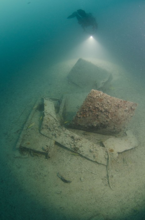
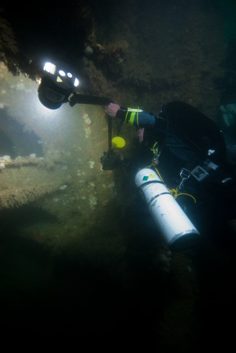
Diver photographs detail of the wreck structure of the Newholm.

Benton_Castle_site_photo

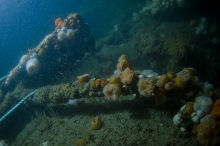
Marine life encrusts the remains of the wreck of the Benton Castle.


Across the Seas: ‘The Idol’, Peña Tú Asturias

Previously we have discussed some 3D-images of  French megaliths. The following 3D image is of a Neolithic stone shelter in Spain.

Located in the beautiful Sierra Plana de la Borbolla, at Llanes in Asturias, Northern Spain, ‘The Idol’ is a neolithic rock shelter which has preserved wonderful examples of prehistoric art.

The rock has been known by local inhabitants for a long time, but it was not until 1914 the first archaeological  investigations took place. ‘The Idol’ can be interpreted as a human form, featuring eyes, nose and feet wrapped in a cloth or robe. It might have represented a tribal elder or warrior, indicated by the adjacent dagger motif, thus making it likely that is was a funerary monument.

The images show crosses, demonstrating the site’s later Christianisation. In addition, we can find a faint animal motif and several red forms throughout.

It is likely that ‘The Idol’ is part of a series of sites dispersed across the region that are almost certainly connected with a wider common culture, stretching from Ireland to Scandinavia to Tunisia, in the Neolithic.

The site was surveyed by drone and Land Rover Defender.

Find this interesting?
Follow us on Twitter
Like us on Facebook

Bouldnor Cliff: A World Class Site

Mohamed Ziad

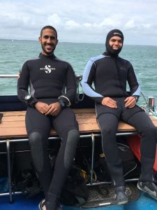
Mohamed and Ziad

Bouldnor Cliff isn’t just important from a British perspective: it is a unique site that interests people from all over the world! The diving team included archaeologists from the Maritime Archaeology Trust and even two divers who’d traveled all the way from Egypt to help with the work and see the remains of the Mesolithic settlement. Ziad and Mohamed flew to Britain when volunteers were needed to join the Bouldnor Cliff survey, and came to help with the photogrammetry work around the site. They’ve done work all around the world, including in Montenegro, Lebanon, Egypt and Italy, but this was their first time diving in the U.K.

Ready for that renowned British summer, Ziad and Mohamed joined the team on the boat, keen to explore the famous site. Undeterred by the wind and rain of the first day (it is summer, after all), they were ready to get stuck in and brave the chilly Solent. Layered up and as prepared as can be for the colder climate they jumped in to get to work. The cold was no match for their enthusiasm and they worked hard, familiarising themselves with the site and the new conditions.

And what did they have to say after their first dive? Ziad had only one word: ‘challenge’!

Now used to the cold and the weather, they carried on diving on the site, contributing hundreds of photos to the photogrammetric survey, and taking footage on a GoPro. Their dedication is such that the skipper even poured warm water into their wetsuits before a dive! Inspired by Ziad’s one-word summary, Mohamed described the site as an ‘adventure’.

Ziad and Mohamed aren’t the only members of the #SaveBouldnor team from abroad – Sarah is from the United States, and Miguel is a PhD student from Lisbon, Portugal. Sarah works at the Maritime Archaeology Trust, and considers the site to be ‘groundbreaking’!

Miguel came to Bouldnor Cliff to gain experience in a new environment, and to improve his skills in 3D reconstruction and recording. Miguel described the site as ‘exciting’ and has contributed a lot of work to the photographic record.

It’s not just maritime archaeologists who find Bouldnor Cliff fascinating – Andy has worked closely with the Trust for fifteen years. He finds the site ‘remarkable’, and, as a long-time diving enthusiast, is helping out on-site.

Bouldnor Cliff is a special site that is always turning up new information and fascinating artefacts. It has something of interest for people from all over the world, from different backgrounds, and this multi-national team has come together to work to save Bouldnor, and learn its secrets. Work like this is invaluable, and will contribute to the continuing record of Bouldnor Cliff, as the MAT monitor the site’s condition and explore new features.

Bouldnor Cliff #3 – Sunken Secrets

This is the last video before we go out diving!

This time Garry is visiting the Sunken Secrets Museum on the Isle of Wight. He shows us various pieces of timber, flint and string that has taught us a lot about the people living here during the mesolithic era. The findings are proving to be highly important, because they show the people were way more advanced than previously thought, by as much as 2000 years.


You can help us save Bouldnor Cliff

Spread the message
Donate now

Older posts