Maritime Archaeology Updates

Diving Deeper with the Maritime Archaeology Trust

Month: July 2016

Model volunteer!

Ken Manchip from the Fareham and District Model Engineering Society tells us how he ended up volunteering for the Maritime Archaeology Trust:

“The road leading to my building of the model steam pinnace started when the Fareham and District Model Engineering Society that I am a member of, played host to a representative of the Marine Archaeologist Trust, how gave us a talk on the underwater world in the Solent: identifying and investigating wrecks. This was received so well that we have left the door open for a return visit.

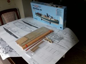
One of the sites the Trust have been researching and surveying in Gosport, Hampshire is the hulked remains of a steam pinnace that would have been in use during the First World War, Steam Pinnace 704. The Trust identified a model kit for a similar vessel and they thought such a model would be a suitable and beneficial aid for public outreach.

They approached the Model Engineering Society to see if we might be able to help with the building and as the representative of the Society’s Marine group the task was presented to me and I very willingly took up the challenge.

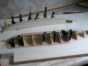
The model kit duly arrived and was found to be a wooden plank on frame, vacuum formed plastic superstructure, and plastic fittings, which I am familiar with. The kit included a side view plan and short explanation of stage build.

Described as a beginner’s kit, it very quickly became obvious that without considerable experience, skills and tooling, this build would have taken more than a month of approximately 2 hours a day and the end result would have been quite different! As with other models that I have been involved in, patience is the main skill to get one through. The moment you recognise what is in hand and where it is expected to go, is magic.

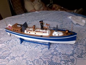
I enjoyed the challenge of building the steam pinnace model, which led me to surf the net to learn more of the history of the naval Pinnaces. The model will be exhibited at the Fareham and District Model Engineering Society Open Weekend at the end of July, before the Trust takes possession for use in their public outreach activities.

And what’s next for me? Maybe I will try the earlier 19th century model?…….”

Ken Manchip, Fareham and District Model Engineering Society

IMG_20160602_155831 IMG_20160604_181916IMG_20160703_143918


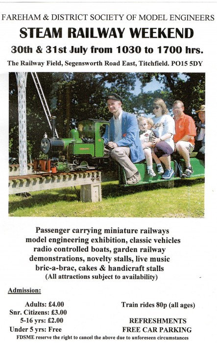
You can see Ken’s steam pinnace model on the weekend of 30/31st July at the Fareham and District Model Engineering Society open weekend:

FDMES_OpenDay2016

Forgotten Wrecks of the Devon Coast: Geophysics and Diving

WholeAreaMap

Distribution of First World War wrecks within the Devon study area (image credit: Contains public sector information, licensed under the Open Government Licence v2.0, from the Maritime and Coastguard Agency).

As part of the Forgotten Wrecks project this summer the Maritime Archaeology Trust sent out a team of divers to find and document a number of WW1 wrecks off the South Devon Coast. In order to assist the divers in finding these wrecks bathymetric maps were consulted. Much like navigational charts used by mariners these maps show the topographic features of the seafloor. However, modern techniques such as multibeam bathymetry, paint a far higher resolution image of the seafloor with measurements made every few metres.  As a result, even fine details such as the orientation of shipwrecks and the positions of larger objects such as boilers and anchors on these sites, can be seen.

Within the area surveyed by the Maritime Coastguard Agency between 2012 and 2015 (data freely available from aws2.caris.com) 31 of the 48 wrecks which had been identified as lying within the south Devon study area reviewed ahead of diving operations were visible.

Once identified a zoomed in map was created of each wreck. The examples shown here are of the British Navy trawler, the Benton Castle and cargo ship, the Newholm. Both of which sank after hitting mines, leading to the loss of 30 lives in total. These images and images of the other wrecks were used by the diving team to help select individual sites to dive and then plan their dives more effectively.

BentonCastle_geophysics

Geophysical survey image of the Benton Castle (image credit: Contains public sector information, licensed under the Open Government Licence v2.0, from the Maritime and Coastguard Agency).

Newholm_geophysics

Geophysical survey image of the Newholm (image credit: Contains public sector information, licensed under the Open Government Licence v2.0, from the Maritime and Coastguard Agency).

The dive team operated out of Dartmouth using Falcon Diving Charters (http://falcondivingcharters.com/) during the week of 27th June to the 1st July. Despite some challenging weather conditions the team managed to reach a number of the Forgotten Wrecks to undertake survey and photogrammetric recording.

Written by Amelia Astley

To find out more about the Forgotten Wrecks of the First World War project, click here.

Newholme_site_photo

Diver photographs detail of the wreck structure of the Newholm.

Benton_Castle_site_photo

Marine life encrusts the remains of the wreck of the Benton Castle.


Across the Seas: ‘The Idol’, Peña Tú Asturias

Previously we have discussed some 3D-images of  French megaliths. The following 3D image is of a Neolithic stone shelter in Spain.

Located in the beautiful Sierra Plana de la Borbolla, at Llanes in Asturias, Northern Spain, ‘The Idol’ is a neolithic rock shelter which has preserved wonderful examples of prehistoric art.

The rock has been known by local inhabitants for a long time, but it was not until 1914 the first archaeological  investigations took place. ‘The Idol’ can be interpreted as a human form, featuring eyes, nose and feet wrapped in a cloth or robe. It might have represented a tribal elder or warrior, indicated by the adjacent dagger motif, thus making it likely that is was a funerary monument.

The images show crosses, demonstrating the site’s later Christianisation. In addition, we can find a faint animal motif and several red forms throughout.

It is likely that ‘The Idol’ is part of a series of sites dispersed across the region that are almost certainly connected with a wider common culture, stretching from Ireland to Scandinavia to Tunisia, in the Neolithic.

The site was surveyed by drone and Land Rover Defender.

Find this interesting?
Follow us on Twitter
Like us on Facebook