[robo-gallery id=”271″]
Maritime Archaeology Updates
Diving Deeper with the Maritime Archaeology Trust
Author: blog-mat-admin (page 4 of 4)
This is the last video before we go out diving!
This time Garry is visiting the Sunken Secrets Museum on the Isle of Wight. He shows us various pieces of timber, flint and string that has taught us a lot about the people living here during the mesolithic era. The findings are proving to be highly important, because they show the people were way more advanced than previously thought, by as much as 2000 years.
You can help us save Bouldnor Cliff
Our second video is out!
This time Sara Rich shows us some timber from earlier Bouldnor excavations and tells us what we can learn from them.
You can help us save Bouldnor Cliff
Take a look at our latest video!
Garry is on the Isle of Wight discussing what we find at Bouldnor Cliff. He shows us what the submerged forests look like and what we can learn about England in the mesolithic era, emphasising the importance of this site.
We are doing our best to retrieve as much as we can before it all erodes away.
You can help us save Bouldnor Cliff.
Spread the message.
Donate now.

Do you have a burning question about maritime archaeology? Have you ever wanted to know what it’s really like to work underwater, or what our team think is the coolest thing they’ve found? Want to find out more about a specific site like Bouldnor Cliff?
Our team are here to answer your questions! Tweet or Facebook us with your questions with #AskTheArchaeologists
Twitter: @maritimetrust
Facebook: maritimearchaeologytrust
All questions will be answered the during the week of the 13th June, live from our dive boat and the Bouldnor Cliff fieldwork, so watch this space!

Are you involved with a school in Dartmouth or the surrounding area? Would you like the Discovery Bus to visit your school?
We are going to be in the area the week beginning 27th June 2016 and are looking for a number of schools who may be interested in a free session on maritime archaeology and the Forgotten Wrecks of the First World War. Sessions available for all age ranges, single classes, or whole year groups. During the session, students will be introduced to maritime archaeology, get to handle real archaeological artefacts from First World War shipwrecks, try on dive kit, and explore what it’s like to be a maritime archaeologist.
For more information or to book a session, please email Jasmine at jns@maritimearchaeologytrust.org or ring us on 02380 237300.
In 1999, whilst out diving, MAT discovered what we know as Bouldnor Cliff by the Isle of Wight. This used to be a highly populated area of land. Ever since the discovery there have been ongoing excavations and investigations to uncover the complex life of the people living on this piece of land during the mesolithic era, about 8000 years ago.

In February we were contacted by a member of the public who’d recently enjoyed a trip to the Caribbean. Whilst there, he’d been diving off the island of St Lucia and visited the wreck of an aircraft. It was, he said, just inside a reef in shallow water but difficult to access as the waves break over the reef in windy weather.
He only had the one opportunity to visit and even then, could not explore the whole aircraft. With no information available from the team who guided him to the wreck, he was curious as to what it may be and, on his return to England, contacted us to see if we’d be able to help.
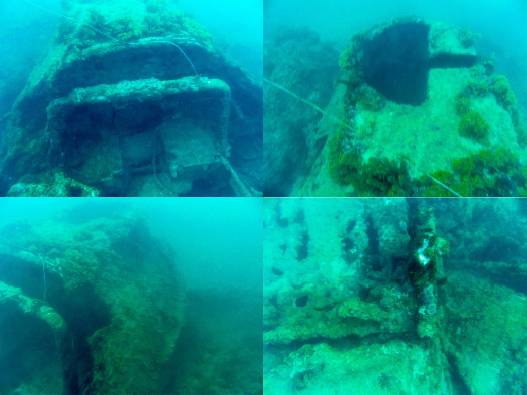
Images courtesy of Alan Foster
His photos illustrate some of the difficulties in maritime archaeology – namely visibility and recording. Not only had the diver been unable to reach the rear of the aircraft, but they hadn’t even been able to see it. Additionally, it is very difficult for someone viewing the photographs later to gauge the scale of the wreck – which is exactly why scale rulers are so important in archaeological recording (not that we would expect a diver on a pleasure dive to take scales with them purely for our benefit!).
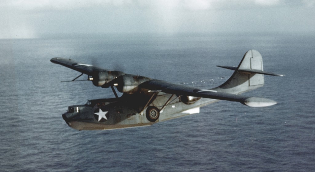
The query was sent through to the Trust’s military history expert, Stephen Fisher. At first it looked like a hopeless task as it was barely possible to work out what any part of the front of the aircraft the photographs were looking at, but Stephen was struck by a solitary feature, visible in the bottom left photograph. This strake reminded Stephen of a similar feature he had seen on the nose of the Consolidated PBY Catalina flying boat, a famous aircraft from the period of the Second World War.
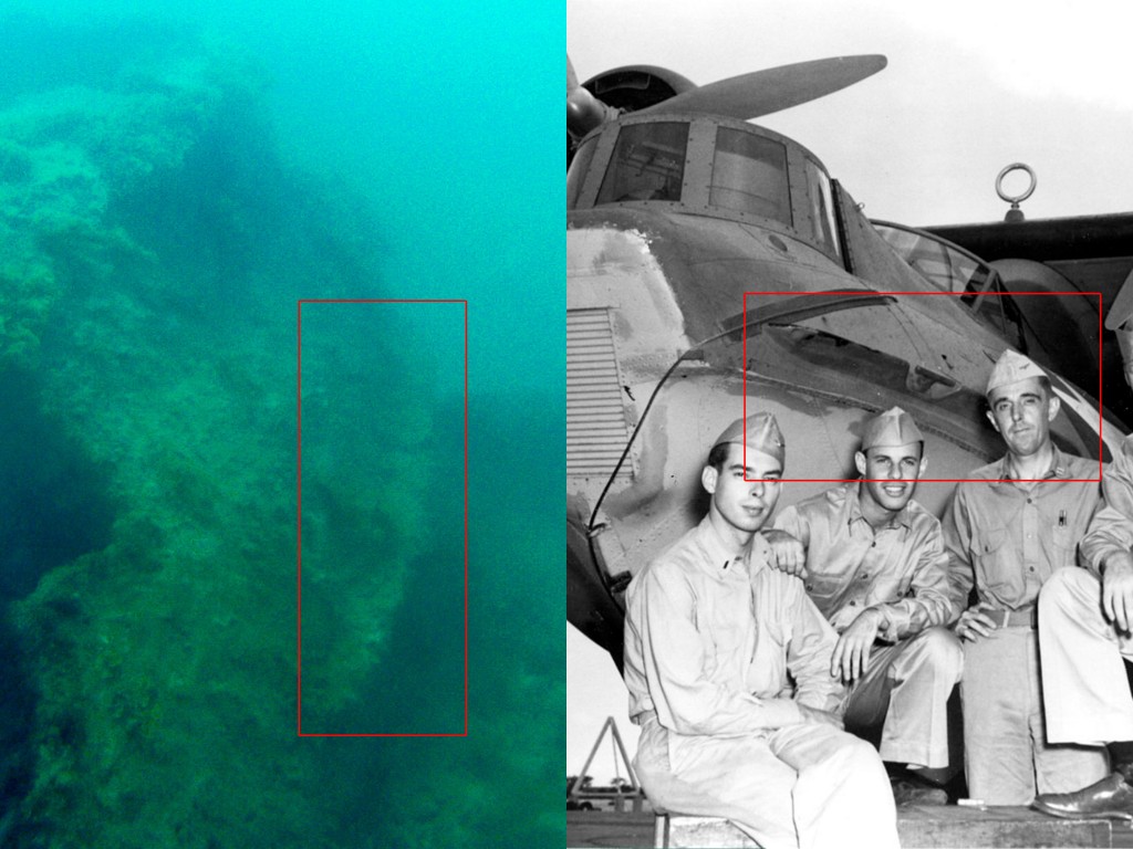
Working on this hypothesis, it didn’t take long to match up the other seemingly random features with the Catalina.
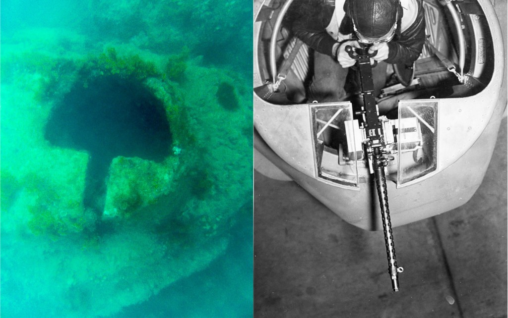
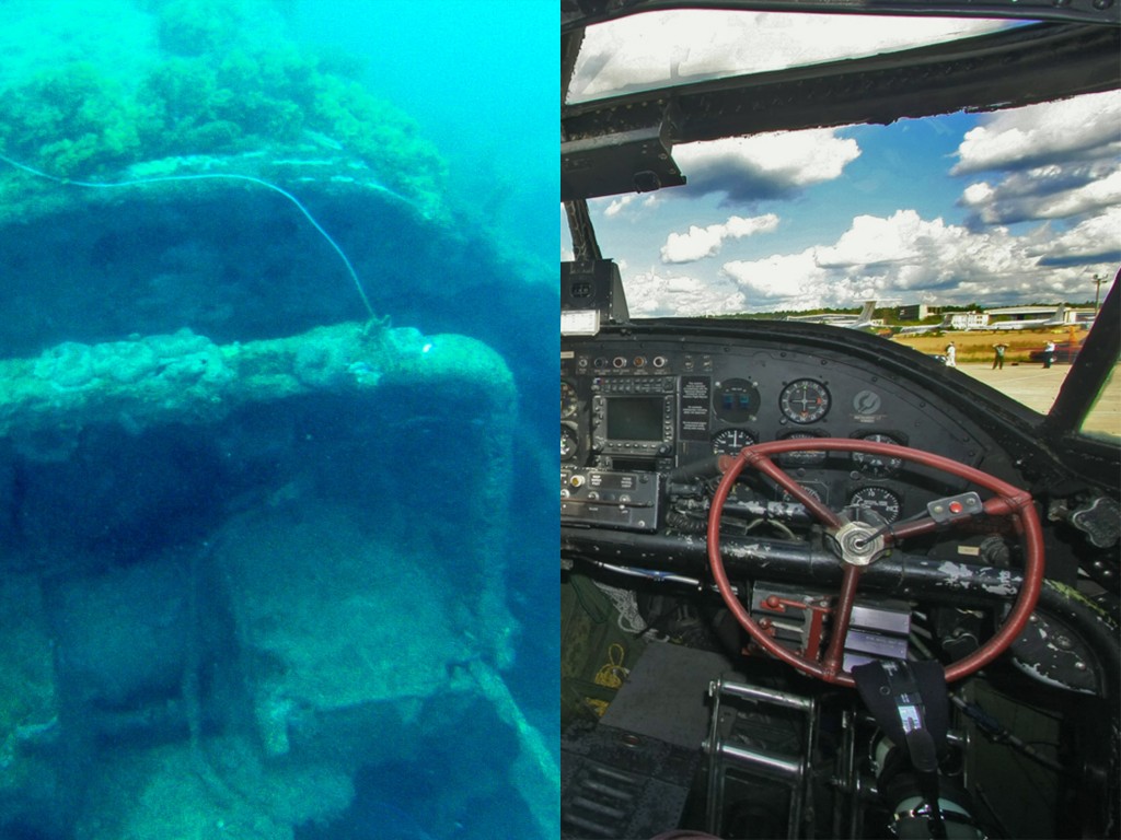
Right hand photo by Aleksandr Markin [CC BY-SA 2.0], via Wikimedia Commons.
With the type of plane now known, it made identifying the actual plane a lot easier. The book BusNos!: Disposition of World War II USN, USMC and USCG Aircraft Listed by Bureau Number by Douglas Campbell lists two possible candidates:
- Aircraft 2400 Consolidated PBY-5 Catalina (Naval Patrol Squadron 31) based at San Juan, Puerto Rico, reported as having ‘water looped during landing and sank 30-Apr-42 at St Lucia’.
- Aircraft 7249, Consolidated PBY-5A Catalina (Naval Patrol Squadron 92) ‘force-landed after engine failure and drifted onto reef and sank 14-May-42 St Lucia.’
There were only minor differences between the 5 and 5A and because of the sheer number of individual variations, even between planes of the same model (such as the forward gun position), it wouldn’t be easy to tell one from the other based on the images. The description of Aircraft 7249 sinking on a reef obviously suggests it may be that one.
The diver has passed all of this information to his contacts in St Lucia. Further research and dives to identify this aircraft can now at least focus on two specific aircraft and look for clues as to which it may be.
With thanks to Alan Foster.
Hello again,
We have been in France researching La Roche Longue, which is a megalith (menhir) located southeast of Quintin, France. We have worked on developing a 3D model of this stone and its surrounding landscape. The model is derived from UAV (Unmanned Aerial Vehicle), commonly known as drone, images, and constructed using photogrammetry. Using a drone allows us to capture detailed images of these large stones which would otherwise be difficult to get from the ground.
La Roche Longue, Quintin, Brittany
by Maritime Archaeology
on Sketchfab
A second 3D model we have been working on is of Allée couverte de Mein-Gouarec à Plaudren. It is a passage grave located near the village of Plaudren in France. Dated around 4,500-4,300 BP, it is a late neolithic piece around 6 meters in length. The tomb features engravings representing the Mother Goddess, including carved out breasts on the back wall. This site was recorded in January this year, using Nikon D200 and D7000 cameras.
Allée couverte de Mein-Gouarec à Plaudren
by Maritime Archaeology
on Sketchfab
The images are all collected as part of the Common Cultural Connections project. The CCC project is a collaboration between MAT in the UK, Centre National de la Recherche Scientifique in France and University of Cantabria in Spain. The aim of the project is to enhance the understanding of the shared cultural heritage through an innovative mobile exhibition. Read more about the project here

Common Cultural Connections
Stay tuned for more about the exciting life of the Maritime Archaeology Trust!
Hi everyone,
We are the Maritime Archaeology Trust, a charitable trust that researches maritime archaeology and heritage. We are forward thinking professionals and researchers who seek to utilise traditional archaeological techniques with new innovative ideas, techniques and technologies. To do this, we combine historical and archaeological studies, with state-of-the-art geoarchaeology, digital technology and 3D modelling.
© 2025 Maritime Archaeology Updates
Theme by Anders Noren — Up ↑
